


Visions of Everest
The 3 Pass Trek
Don't have 3-weeks?
Heli out early from Everest Base Camp
Why Our Guests Love This Adventure
The Sacred Three: Kathmandu’s icons—the towering Boudhanath Stupa, the hilltop "Monkey Temple" (Swayambhunath), and the ancient riverside rituals of Pashupatinath.
Service with Spirit: Go beyond the trail at the Kakani Village Secondary School. Help implement a real-time needs assessed project.
The "Inside" Track: Skip the tourist traps. Enjoy an Insider Scoop on local life, hidden gems, and deep-rooted stories shared by our dear friends in the heart of Kathmandu.
The Triple Crown (Optional): Test your lungs and grit on three legendary high-altitude peaks: Chhukung Ri, Gokyo Ri, and Kala Patthar.
The Throne Room: Stand in the literal shadow of giants with unrivaled views of Everest, Lhotse, and Ama Dablam.
The World’s Highest Stage: Touch the heart of Everest Base Camp.
Fuel for the Soul: From steaming Momos and bottomless Dal Bhat to the world’s highest bakery treats, the Himalayan flavors are as unforgettable as the views.
Join the Karuna Project for a masterclass in Himalayan wonder as we journey into the Khumbu Valley, the literal 'Throne Room of the Mountain Gods.'
Having led 15 expeditions across India, Tibet, and Nepal, expedition leader Seth returns to his favorite corner of the globe. Why? Because Nepal is more than a destination; it is a pulse. It is the rhythmic clanging of yak bells on suspension bridges, the scent of ritual juniper smoke, and a spiritual undertone that vibrates through the very granite of the world’s highest peaks.
This isn't just a trek; it’s a bridge between worlds. You’ll stand in the shadow of giants like Everest, Lhotse, and Ama Dablam, but you’ll also sit in the heart of our Karuna Project community development sites. Here, compassionate action meets reality. Through near-term needs assessments, you won't just witness change—you will be part of the tribe that shapes it.
Step into a landscape where geography meets divinity. Join the tribe. Be the change.
$4,600 USD per person double occupancy
+$610 single supplement available in Kathmandu only
+$900 helicopter out from Everest Basecamp & fly home early
Dates: Nov 1st - 21st, 2026
or early out Nov 14th
Trekking Days: 15-days (9 with heli out) includes 3 acclimatization days
Trekking Distance: 112 Miles
(180 Kilometers)
Serenity: Medium Level
Popular trek on less traveled trails
Accommodations: Tea house accommodations on trek. No tent camping. 3-star boutique hotel in Kathmandu.
Trip Length: 21-days (14 with heli out)
Altitude: Multiple days reaching 18,000+ ft (5,400 m)
3 high-altitude passes
3 optional peak ascents
& Everest Basecamp
Views: Phenomenal Khumbu Himal Views, including Everest!
Group Size: 6-15 people
Difficulty: High Level
Numerous high-elevation and consecutive hiking days!
A $1,000 deposit is required to hold your spot.
International flights are not included.
Daily Itinerary


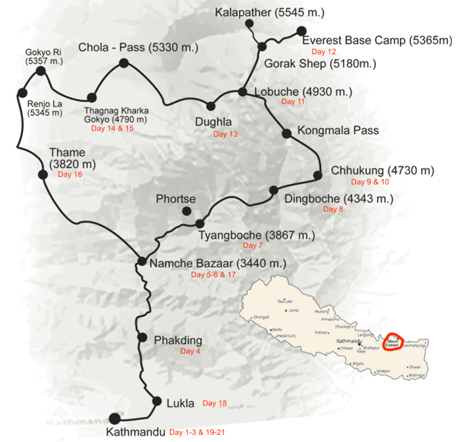
Route Maps

For the Detail Lovers
Trip
Discounts!
Refer friends or family on your trip or any Karuna trip and receive a $75 credit. More than one referral receives $100!
Returning clients, we are so glad you're back for more! Enjoy 5% off any trip.
Early bird save $75 if you register before April 1st.
Local to our home in the Gunnison Valley, Colorado? We have something for you!
Give Back! Adventure for a cause, get $50 to $400 off when you fundraise for a life changing cause. Let your bucket overflow! LEARN MORE
Yes!
You can combine discounts
Itinerary Changes &
Mandatory Travel Insurance
All trips are subject to itinerary changes based on a variety of circumstances, including, but not limited to, permit availability, extreme weather, political or bureaucratic obstacles, earthquakes, etc. Payments are not refundable based on itinerary changes; they are only refundable on cancellations based on the cancellation policy. We require everyone to purchase travel insurance to cover unforeseeable travel plan disruptions such as illness, flight delays, natural disasters, political and bureaucratic unrest, etc.